EXECUTIVE SUMMARY
The Hawaiian cultural practice of making salt is one of Hawai‘i’s oldest traditions and Hanapēpē Salt Pond is one of the last places in all of Hawaiʻi that continues this tradition. The area and practice is highly treasured and protected by the salt makers as well as the larger community. Over the years this cultural practice has been threatened by increased marine and rainfall flooding (as well as user conflicts and nonpoint pollution) during the summer months, when ideal salt-making conditions require the Pond to be hot and dry.
Throughout 2018-2022 a team of specialists, researchers, and practitioners were assembled and included the University of Hawai‘i Sea Grant College Program Kaua‘i Coastal Land Use Extension Specialist, representatives of the Hui Hana Paʻakai o Hanapēpē, the University of Hawai‘i Hui ʻĀina Momona, and University of Hawai‘i researchers from the School of Ocean and Earth Science and Technology (SOEST) to conduct a hydrogeologic investigation at Hanapēpē Salt Pond. The study was geared toward determining the subsurface geomorphology and developing a groundwater model based on environmental monitoring data and the use of state-of-the-art hydro-geophysical techniques to provide:
- A water budget for Salt Pond that measures inflows, outflows, and storage to characterize the overall system.
- An evaluation of the relative magnitudes of surface flows versus subsurface flows to help determine the dominant source of flows to the pond.
- An assessment of causes for flooding (inflows vs. outflows) and causes for slow drainage to determine potential mitigation actions.
- Characterization of coastal processes that reveal the influence from marine wave overtopping of the beach and include projections of future conditions under various sea level rise (SLR) scenarios.
- Recommended mitigation actions and adaptation strategies designed to address the long term success of salt harvesting in the area.
Geophysical and geochemical observations in the pond revealed ~9 ft thick clay layers with very limited hydraulic conductivity (a property that describes how quickly water flows through the subsurface). The observations illustrate that the clay layers allow very little subsurface flow to take place, facilitating evaporation and in-turn, the concentration of salts. The pond is able to exchange water with the ocean. Specifically, the clays allow for a slow drainage of water from the pond, while at the same time allowing ocean intrusion; hence water level keeps up with tides, albeit at a dampened pace. This finding implies that larger marine flooding events of the pond occur via overtopping of the beach berm, and that drainage through the clay layers is very slow.
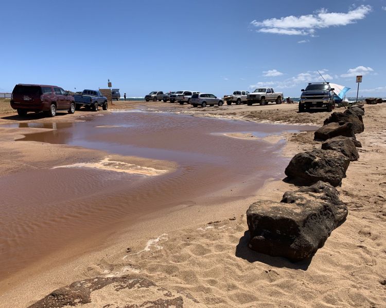
Based on kilo observations from the salt making community, wave overtopping of the beach berm occurs during periods of large summer swell and high tides, and the magnitude increases when the beach berm is deflated. This situation occurred when vehicles were allowed on the beach and compacted the sand. When waves overtop the berm, dilution of the salt ponds can occur, which interrupts salt formation and harvest. Currently, the biggest flood threat to the practice of making salt, which occurs in the summer dry months, is wave overtopping of the beach. The blocking of vehicles from the beach has resulted in passive restoration of the beach berm, which has reduced the amount of marine flooding over the beach.
As sea level continues to rise, erosion is projected to narrow the beach beyond what was experienced during vehicle induced erosion. To allow saltmaking to continue as long as possible in its present location, it’s important for vehicle use to remain restricted. However, the vehicle induced erosion provided a glimpse into how SLR related erosion will impact the salt ponds in the near future.
The current focus of mitigation measures should be on the health of the beach and restoring the dune. As marine flooding becomes more of an issue in upcoming decades, consideration should be given to producing new salt pond sites slightly inland of where they’re currently located. Doing so may allow the salt making practice on the peninsula to extend into future decades.
As sea level rises it is also expected that slow/limited subsurface ocean intrusion will force water level in the pond to increase. Rainfall induced flooding (including runoff) primarily occurs during the winter months when salt making is not occurring. However, as global temperatures continue to rise causing climate changes, rainfall patterns are shifting. It is recommended to monitor the changing rainfall and groundwater rise in the pond with a weather station and traditional kilo methods.

Figure 1. Photo of flooding from wave-overtopping the beach berm, which is lined by vehicles in 2019.


